This survey was carried out using a satellite photograph and geographic co-ordinates taken from Google Earth. The triangulation and area computations were effected by a program written in Java, whose adequate functionality can be verified from its source code.
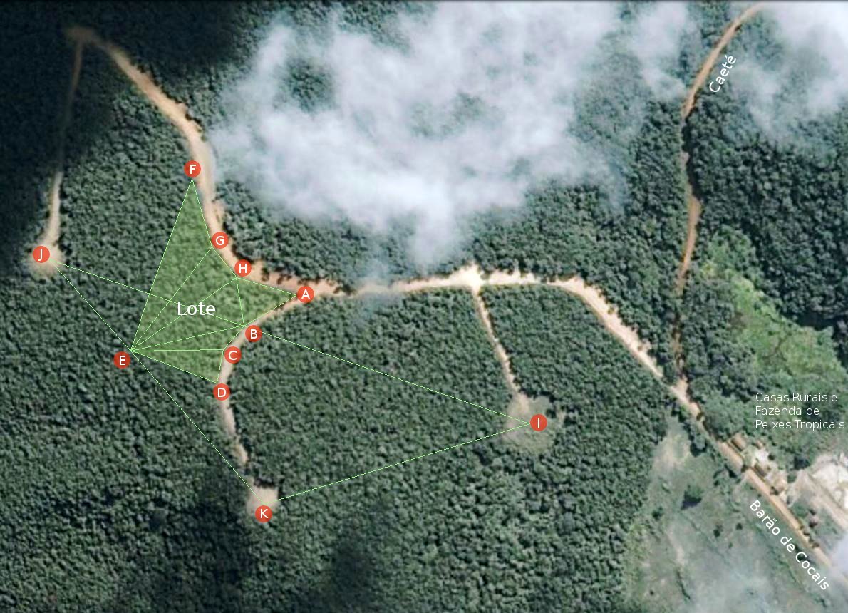
 The only information we had about the plot of land Jes had bought and paid for in full was our memory. To get there, we had travelled along a dirt road from Caeté to Barão de Cocais. About 15 km out of Caeté was a fork in the track just before a tropical fish farm next to a group of small rustic rural houses. Straight on at the fork continued to Barão de Cocais. Doubling back to the right led to the location of Jes's plot. We had once been taken on foot by Itamar Melgaço along this dirt road. We took the second turning on the left. It was a dirt track. Itamar Melgaço pointed out Jes's land as being the first plot on the left along this dirt track. From this scant information, I was able to locate this general area using Google Earth.
Note: On both the general area image (accessed by clicking the link above) and the small-area image of the plot (above right), the effective eye height is 1600 metres vertically above the plot and the scale of the image is 0·475 of a metre per pixel.
The contract specified that the amount of land Jes had (supposedly) bought was 5000·30 m². Bearing in mind that it was the vendor's intention to fit other similar plots of land around the dirt tracks, I attempted to fit a 5000 m² area, as best I could, in the position that had been indicated to us. Appropriate points were therefore marked on the Google Earth image and the latitude, longitude and altitude of each point was noted as shown in the table below:
| Point | Latitude | Longitude | Height |
|---|---|---|---|
| A | 19 53 47·18S | 43 32 28·18W | 1114 |
| B | 19 53 47·81S | 43 32 29·24W | 1118 |
| C | 19 53 48·27S | 43 32 29·65W | 1120 |
| D | 19 53 48·95S | 43 32 29·78W | 1121 |
| E | 19 53 48·29S | 43 32 31·61W | 1120 |
| F | 19 53 44·84S | 43 32 30·39W | 1114 |
| G | 19 53 46·22S | 43 32 29·93W | 1117 |
| H | 19 53 46·84S | 43 32 29·41W | 1117 |
| I | 19 53 49·78S | 43 32 23·16W | 1114 |
| J | 19 53 46·50S | 43 32 33·29W | 1122 |
| K | 19 53 51·30S | 43 32 28·75W | 1126 |
The letters in the table refer to the points so marked on the satellite image of the general area. Construction lines join the visually recognisable points I, J and K. These were used to position the key boundary points B and E. Point A is a self-evident reference point as well as a boundary point. Points D and F were adjusted to yield an area of around 5000m². Points C, G and H were then introduced to fit the plot to the curves of the bounding roads.
The boundary lines were drawn and the plot was divided into suitable triangles for the purpose of computing its area. The positions of the non-referenced boundary points (G, H and C) were then adjusted in steps of 0·01 of a second of arc until an area closest to that stipulated in the contact (5000·30m²) was obtained.
| Triangle | Side1 | Side2 | Side3 | Area |
|---|---|---|---|---|
| ABH | 36·29 | 30·39 | 37·36 | 509·39 |
| BEH | 70·48 | 78·10 | 30·39 | 1069·70 |
| BCE | 18·56 | 56·98 | 70·48 | 401·46 |
| CDE | 21·36 | 56·98 | 56·98 | 597·74 |
| EGH | 80·50 | 24·41 | 78·10 | 951·74 |
| EFG | 112·40 | 44·71 | 80·50 | 1469·67 |
The adjacent table gives the 3 points that define each triangle, the lengths of its three sides in metres and its area in m². The areas are computed by the Java triangulation program using the Heron formula. Computation is done in IEEE 754 floating point double (64 bit) precision.
Total area of the surveyed land closest to the 5000·30m² stipulated by the contract was 4999·70 m². This represents an error in the area of the whole plot of only -0·60 m², which is equivalent to a square of side 0·77 metres.
In order to effect its computations, the program calculates the radius of the Earth at the mean latitude of the purchased plot, which in this case is 6376781·55 metres. This radius includes the mean elevation of the purchased plot above sea level, which is 1118 metres.
The positions of the boundary points of the plot of land are expressed to a precision of 0·01 seconds of arc. This implies that the geographic information source (Google Earth) has an underlying accuracy of ±0·005 seconds of arc. Within this plot of land and its vicinity, as calculated by the program:
0·01 second of latitude = 30·92 cm.
0·01 second of longitude = 29·07 cm.
This is well within the ±50cm accuracy required by INCRA, the Brazilian rural land authority.
The best attempt at fencing an area of 5000·30 m² (the area specified in the contract) was 4999·70 m² as shown above. Shifting boundary point 'A' 0·01 second of longitude (i.e. in an East-West direction) changed the enclosed area by around 1·5 m². Shifting it 0·01 second of latitude (i.e. in a North-South direction) changed the enclosed area by 4·5 m². Shifting other points by 0·01 second of arc caused the area of the plot to change by as much as 10 m².
Consequently, due mainly to its extremely awkward shape, the area of the plot can only be safely expressed as: 5000±10m². However, this is officially accepted as more than sufficiently accurate for the measurement of areas of rural land. The achievement of greater accuracy would require the use of Total Station technology and physical access to the plot, which was not permitted by the vendor.
 The motive for buying this plot of rural land was to construct a research eco-residence that would blend with the natural forest and draw its necessities sustainably from the land. It has a benign geometrical design and is made of a high-tech material produced from naturally available ingredients. The eco-residence has internal means for growing food with enhanced soils and hydroponics. The residence is situated within a 2000m² landscaped area, which leaves the mandatory 60% of the plot as natural forest. The image on the left shows the eco-residence in its proposed location within the plot.
